roads in the USA

by Fathom.info, makers of Processing HT @traviskolton

Compare to those famous light maps of the USA:

https://i0.wp.com/cdn2.sbnation.com/imported_assets/721758/image_thumbnail_aspx.jpg

http://dmsp.ngdc.noaa.gov/pres/low_light_120701/images/USA_29.GIF

usa_small.jpg

http://dmsp.ngdc.noaa.gov/pres/low_light_120701/images/USA_POS.GIF

Thumbnail goes

Other nice ones on the same topic. You can’t compare visually to the “new view” of the roads vis-à-vis the lights, but who doesn’t love looking at these pics? I don’t want to leave most of the world out just because the US produces the most data.

Don’t have a roads pic of the world but here’s a lights-at-night pic of the world:

https://i0.wp.com/aidwatchers.com/wp/wp-content/uploads/2011/01/Lights-at-night.png

https://i0.wp.com/www.giss.nasa.gov/research/news/20011105/flat_earth_nightm.jpg

https://i0.wp.com/www.giss.nasa.gov/research/news/20011105/usa_nightm.jpg

https://i0.wp.com/www.giss.nasa.gov/research/news/20011105/europe_nightm.jpg

Europe:

Photograph from satellite data showing nighttime lights throughout Europe.

European Night Lights

A recently released satellite picture from NOAA illustrates the changes in nighttime lights in Europe between 1992 and 2009. Yellow regions show where lights have increased, purple places indicate where lights have decreased, and white areas show no change.

https://i0.wp.com/eol.jsc.nasa.gov/sseop/images/EFS/lowres/ISS023/ISS023-E-29061.JPG

https://isomorphismes.wordpress.com/wp-content/uploads/2012/10/9a4bc-franceitalybordersmall.jpg

Mother India:

http://www.ngdc.noaa.gov/dmsp/image/india_03_98_92_a.jpg

https://i0.wp.com/eoimages.gsfc.nasa.gov/images/imagerecords/55000/55167/earth_lights.gif

And some O(10MB) images of the world at night: http://visibleearth.nasa.gov/view.php?id=55167

https://i0.wp.com/img1.jurko.net/wall/paper/earth_at_the_night_1024x768.jpg

Photograph from satellite data showing nighttime lights throughout Europe.

Nighttime satellite image of Europe, derived from U.S. Air Force Defense Meteorological Satellite Program (DMSP) Operational Linescan System (OLS).

https://i0.wp.com/images.texas.ynn.com/media/weather/onair/0727-london_lights_at_night.jpg

Map of night lights showing the growth of urban lights in Europe between 1992 and 2010.

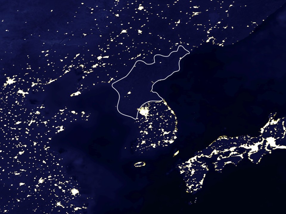
Dear Heavenly Leader in North Korea keeping the light pollution down:

https://i0.wp.com/whyfiles.org/wp-content/uploads/2012/01/citylights_china.jpg

links may be broken on this one, but promises dark-sky pics of SA, ME, Africa, and some “remote” (primitive living) areas

Back to the USA roadmap by Fathom.info, here’s San Francisco:

Appalachia:

Interesting twitters, if you like this, are @fathominfo and @impure140. (Impure being another visual programming language besides Processing.)

Leave a comment